Saturday, January 4th Forecast: It arrives tonight. Ice and Snow Storm Details
If you have any errands to run or grocery shopping left to do, then today is the day to knock it out. While conditions won't be lovely, it's far better than what will be waiting for us tomorrow. Grey clouds will dominate the skies for today with winds gusting over 20 mph. Temperatures will be [...]

If you have any errands to run or grocery shopping left to do, then today is the day to knock it out. While conditions won't be lovely, it's far better than what will be waiting for us tomorrow.

Grey clouds will dominate the skies for today with winds gusting over 20 mph. Temperatures will be chilly. Our thermometers will only climb a few degrees above freezing today with feel-like temps trapped in the 20s.


The winter storm is set to arrive later tonight just a couple hours before midnight. This storm has two massive stages we have to get through. The first is ice.


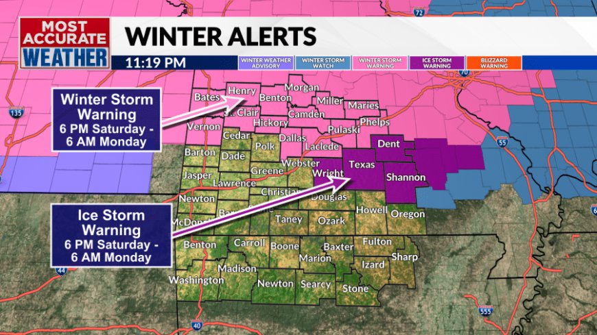
Freezing rain and sleet will fall mainly north of Highway 60 tonight and into the morning hours on Sunday. Right now, I am pinpointing Webster, Wright, Texas, Laclede, and Pulaski counties as the locations to experience the highest ice accumulation. For these spots I will not be surprised to see over 0.50" of ice. With that being said, the majority of people will see 0.1-0.25" of ice accumulation.

To put those numbers in comparison the Historic Ice Storm of 2007 dropped over 2" of ice across the Ozarks. I believe, worst case, we will only witness a quarter of that. Yes, that is enough ice to create power outages. Thankfully, I believe any power outages will be spotty rather than a widespread blackout.


South of Highway 60 temperatures are forecasted to be just slightly above freezing. While people to the north will be getting ice, to the south only a cold rain to start the day.


By the time we get into the afternoon, ice will no longer be a concern as we will see a transition into snowfall.
Unlike the ice, everyone in the Ozarks has a chance to see at least flurries coming. Snowfall totals start to drastically increase the further north you travel. I am placing Springfield in the range of 1-2".

Please stay inside on Sunday. Do not drive on the roads unless absolutely necessary as conditions will be slick. While the winter storm concludes Sunday night road conditions will still be poor to start the day Monday, especially any untreated paths.


We will not be thawing out on Monday as an arctic air mass grabs ahold of us. High temperatures will be limited to the lower 20s on Monday, Tuesday, and Wednesday. To make things worse the overnight low temperatures will decrease to the single digits with subzero wind chill. The Ozarks have not been that cold in roughly 350 days.
Updates will be provided here and on our weather app. Click the link above to download. Stay safe. Stay warm. And please do try and enjoy the snowfall.
What's Your Reaction?


