Tuesday, December 31 forecast: New year, new pattern and it could come with a winter weather risk
We're just about set to turn the page from 2024 to 2025, and with the new year, we find ourselves in a new pattern. It's a colder one and it looks like it will get colder and possibly more wintry. Stubborn clouds will gradually shift east tonight into Wednesday morning, and as we ring in [...]

We're just about set to turn the page from 2024 to 2025, and with the new year, we find ourselves in a new pattern. It's a colder one and it looks like it will get colder and possibly more wintry.


Stubborn clouds will gradually shift east tonight into Wednesday morning, and as we ring in the new year we can expect a cold and quiet midnight forecast with temperatures a little below freezing.

New Year's Day is shaping up to be much brighter with mostly sunny skies expected. Temperatures will climb into the low 40s.

An approaching cold front Thursday will generate a wave of cloudier skies Thursday. Some sprinkles or a light mist is possible with the clouds, mainly north of Hwy. 60. Temperatures will run near to above normal with highs in the mid to upper 40s. Areas to the south, where it should be a bit sunnier will likely see highs close to 50°.
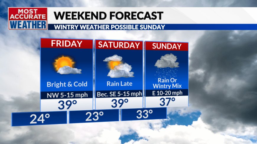
Colder weather will follow as we wrap up the week with a bright and cold Friday expected. The chill will linger into the weekend as a storm approaches from the west.


Saturday will be our transition day with clouds quickly moving in. Precipitation will tend to hold off until late Saturday.
The early indicators point to a possibility of rain or a wintry mix that changes from a wintry mix to snow towards the end. The risk of heavy snow appears highest near I-70. We'll have to watch for icy weather further south across Central Missouri, possibly extending into South Central Missouri. For Southwest Missouri, it looks like a cold rain that eventually transitions late in the day to a wintry mix and then snow Sunday night. Mainly rain is expected across Northern Arkansas.
Accumulations of ice and snow are possible and travel impacts are on the table, so remain weather-aware as we approach Sunday.

The departing storm will also leave behind very cold weather. This will be the beginning of a very cold stretch of weather with most if not all days next week remaining below freezing.
What's Your Reaction?


