Thursday, January 9 forecast: Snow is here! Winter snow storm forecast
**UPDATE** See the links below for road conditions and the latest school closings before, during, and after the winter storm. -Check HERE for the latest road information from MoDOT-Check HERE for the latest school closings Steady snowfall is occurring across the Ozarks. Everyone will be getting snowfall tonight with snow-covered conditions for the morning hour. [...]

**UPDATE**
See the links below for road conditions and the latest school closings before, during, and after the winter storm.
-Check HERE for the latest road information from MoDOT
-Check HERE for the latest school closings
Steady snowfall is occurring across the Ozarks. Everyone will be getting snowfall tonight with snow-covered conditions for the morning hour.

The recipe is ideal for heavy accumulation. With temperatures well below freezing every snowflake will stick. Additionally, winds are light with no concern of ice/sleet.


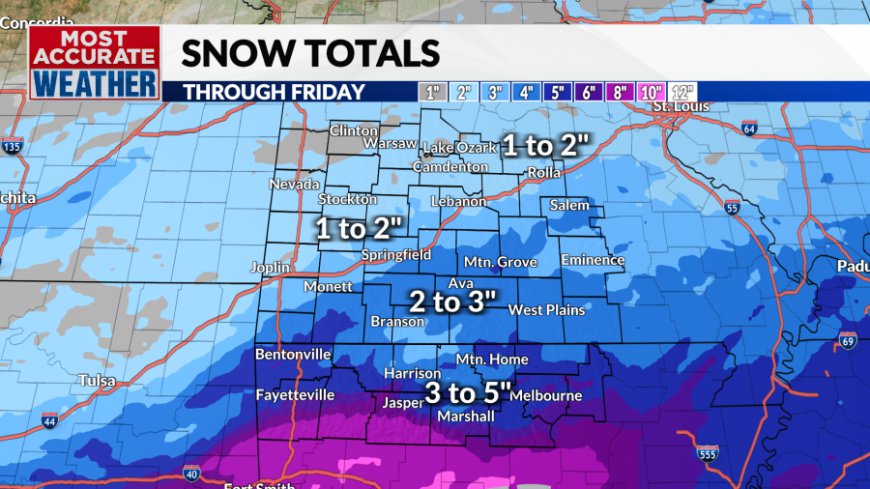
Totals will be impressive for the majority of the area. Heaviest amounts will occur to the south where 4-6" of snowfall will be possible. 2-3" is a more realistic estimate for areas north of i-44. Here in Springfield, I expect 3-4 inches to fall.


Enjoy the snowfall tomorrow. We will be above freezing both days this weekend quickly melting away all snowmen.

One winter storm down and one more to go. Snow is coming tonight into Friday and is expected to accumulate easily in the Ozarks.

High-level clouds quickly took away our sunshine this morning. This will have an impact on our temperatures today. We'll do our best to reach freezing today, but the clouds may prevent it from happening. It'll be close.


A winter weather advisory and a winter storm warning have been issued for large swaths of Missouri and Arkansas in anticipation of snow tonight.

Snow showers will begin this evening and last through Friday morning before tapering off into snow flurries Friday afternoon. The heaviest snow is expected across far southern Missouri and south into Arkansas. A general 1" to 3" is expected north of the state line with 3" to as much as 5" across Northern Arkansas.


Confidence is high that any snow that does fall will accumulate easily. Snow-covered roads are likely on Friday morning. Temperatures won't warm much with highs near freezing. Roads will probably become slushy before refreezing again Friday night.

This will be a much more impactful storm to the south across Arkansas and into other parts of the South. Amounts will be greater and resources to deal with snow and sleet on roads are much more scarce. This will make travel inadvisable late Thursday into the weekend across Arkansas into North Texas and east into Mississippi.


We'll see back-to-back above-freezing days this weekend. This will be an opportunity to melt some of the snow.

What's Your Reaction?


